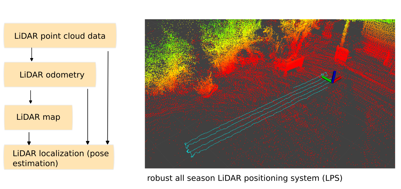
Robust All-season LiDAR Positioning System (LPS)

 Most LiDAR-based positioning systems are designed for indoor use and fail when the environment changes extensively, which is rare indoors. In outdoor use, however, it is important that the local location can be determined precisely even when the environment changes. Just by changing the vegetation, by pruning trees and mowing grass, prominent points of the map may be obscured and new ones will be created. A LiDAR-based outoor positioning system must be able to detect and handle all of this over seasons. Our owlLPS is designed for this special "year-round capability".

Features:

  • requires only a low-cost LiDAR (e.g. Livox MID-360 or LSLIDAR-C16)
  • high-precision 3D LiDAR odometry (typical +/- 2cm)
  • outdoor and indoor across several floors (small and large 3D areas with thousands of square meters, across floors)
  • robust localization system (localization works between seasons, e.g. localization at winter time against a summer map and vice versa with typical localization accuracy +/-10cm in changing outdoor environments and +/-2 cm in static environments)
  • optionally, GPS-RTK can be added to improve localization performance in very open areas (>100m) with no objects in the environment (alternatively, objects like traffic cones can be added to very open areas for LiDAR-only localization) 
  • based on open source code (robotic operating system ROS)


To make the best use of resources and thus save money at the end of the day, you need to know what the current state of your infrastructure is. The owl Robotics Sensor Value Mapping helps to measure values on an area and to display them with centimeter accuracy in a map of the area, as a heat map.
With this precise representation, for example, a farmer can optimize the use of fertilizer in the field, a company can ensure the coverage of his wireless network on the company premises, a fruit grower can optimize the use of his irrigation system to save water and many other applications.
The navigation hardware and software can be installed in an autonomous robot that permanently scans the surfaces and determines the values, or on any other vehicle that can be used to take measurements, such as a forklift that measures the permanent WiFi quality in a warehouse or the quality of the air.

heatmap.jpg

About owlRobotics GmbH

owlRobotics GmbH stands for high precision navigation algorithms for self driving robots like lawn mowers and similar vehicles, based on our Sunray-OS or open standards.

We use cookies

We use cookies on our website. Some of them are essential for the operation of the site, while others help us to improve this site and the user experience (tracking cookies). You can decide for yourself whether you want to allow cookies or not. Please note that if you reject them, you may not be able to use all the functionalities of the site.